Presque Isle State Park
Presque Isle State Park is a 3,112-acre Pennsylvania State Park located on a curved, sandy peninsula that extends into Lake Erie, about 4 miles west of Erie, in Millcreek Township, Erie County, Pennsylvania. The peninsula curves northeastward, surrounding Presque Isle Bay along the park’s southern coast. It boasts 13 miles of roads, 21 miles of recreational trails, 13 swimming beaches, and a marina. Popular activities at the park include swimming, boating, hiking, biking, and birdwatching.
The history of Presque Isle can be traced back to the Erielhonan, a Native American tribe known for giving their name to Lake Erie. This region has also been influenced by French, British, and American forts, and was used as a base for Oliver Hazard Perry’s fleet during the War of 1812. As shipping on Lake Erie became more important in the 19th century, Presque Isle became home to several lighthouses and eventually a United States Coast Guard station. In 1921, it was designated as a state park and has since become a popular destination, attracting over 4 million visitors annually, making it the most visited state park in Pennsylvania.
The formation of the Presque Isle peninsula is attributed to a moraine left over from the Wisconsin glaciation and is continuously altered by the effects of wind and waves. This has resulted in the development of seven distinct ecological zones within the park, which serves as a prime example of ecological succession. Recognized as a National Natural Landmark in 1967, the park is renowned for its exceptional bird watching opportunities, particularly at the Gull Point Natural Area. Visitors can also gain a deeper understanding of the park and its ecology at the Tom Ridge Environmental Center located at the park’s entrance. Presque Isle State Park has been included on the Pennsylvania Bureau of Parks’ list of “25 Must-See Pennsylvania State Parks”.
History
First Residents
Roughly 11,000 years ago, Presque Isle emerged following the Wisconsin glaciation. According to sources, the Erielhonan, also referred to as the “Eriez”, were the earliest inhabitants of the southern coast of Lake Erie. This tribe, which spoke an Iroquoian language, was known as the “Cat” or “Raccoon” people. The name “Erie” was derived from “Erielhonan” and eventually became the name of both the lake and county where Presque Isle Park is located, as well as the nearest city.
According to an Erielhonan legend, the Great Spirit guided them to Presque Isle because of the abundance of wildlife, the plentiful supply of clean water, and the refreshing breezes from the “land of snow and ice” (also known as Canada). Another legend tells of how the Erielhonan set off into Lake Erie in search of the land where the sun sets, but the spirit of the lake conjured up a fierce storm to prevent them from reaching it. To shield the Erielhonan from the storm, their deity extended his arm into the lake, providing them with shelter during the tempest. The deity’s arm remained in the lake, guarding the tribe’s future generations.
It is believed that the Erielhonan people inhabited the peninsula and practiced agriculture. They engaged in multiple battles, including a final conflict in 1653 against the Iroquois Confederacy. Despite initial successes against the Seneca tribe, the Erielhonans suffered a major defeat in 1654 when their largest village, Rique, was destroyed by 1,800 Iroquois warriors. Eventually, by 1656, the Erielhonan people were completely wiped out, although some survivors were taken in by the Seneca tribe.
Forts, pioneers, and the War of 1812
In the 1720s, the French were the first to give a name to the peninsula, known as presque-isle which means “almost an island” in French. They established Fort Presque Isle in the modern-day city of Erie during the summer of 1753, naming it after the peninsula that provided protection for the fort. Additionally, the French also constructed two “military outposts” on Presque Isle itself, with one at the entrance and the other at the eastern point. However, during the French and Indian War, the French abandoned their outposts and destroyed their fort in 1759.The British then built a new fort with the same name that year, but it was captured by Native American forces on June 19, 1763, during Pontiac’s Rebellion.
After the end of the American Revolutionary War, control of Presque Isle was transferred from the British to the Americans. The Iroquois relinquished their rights to the land on the peninsula and sold it to the United States during the second Treaty of Fort Stanwix in 1784. It wasn’t until April 3, 1792 that Pennsylvania obtained clear ownership of the land when they purchased the Erie Triangle from the federal government. In 1795, General Anthony Wayne constructed a new American “Fort Presque Isle” and the nearby town of “Presqu’ Ile”, which is now known as Erie, was established. General Wayne passed away at the fort on December 15, 1796 and was originally buried there.
Erie County was established from Allegheny County on March 12, 1800. One of the original townships, Millcreek Township initially encompassed both the Presque Isle peninsula and the village of Erie. In 1803, Erie was designated as the county seat, eventually becoming a borough in 1805 and a city in 1851.
During the War of 1812, Presque Isle played a crucial role in the defeat of the British in the Battle of Lake Erie. The commander of the American fleet, Oliver Hazard Perry, strategically utilized the bay to build six out of nine ships. This location served as a defensive barrier, forcing potential attackers to take a longer route around the peninsula to reach the fleet.
The area known as “Little Bay,” located near the peninsula’s tip where ships would take shelter, was given the name “Misery Bay” due to the hardships endured during the winter of 1813-1814. This was when returning soldiers were struck with smallpox and had to be quarantined near the bay. Many of these infected men did not survive and were laid to rest in what is now known as Graveyard Pond.
After the Battle of Lake Erie on September 10, 1813, the two largest ships of Perry were heavily damaged. As a result, the US Brig Lawrence was deliberately sunk in Misery Bay. In 1875, the Lawrence was brought up but was later destroyed by fire while being exhibited at the Centennial Exposition in 1876. On the other hand, the US Brig Niagara was initially repaired after the battle, then intentionally sunk for preservation in 1820. It was finally raised in 1913 and some of its parts were eventually utilized in the present-day Niagara, which is located on the other side of Presque Isle Bay in Erie.
Coast Guard and Lighthouses
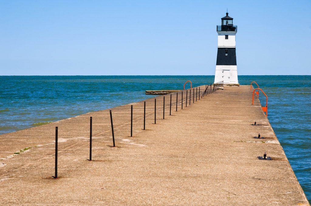
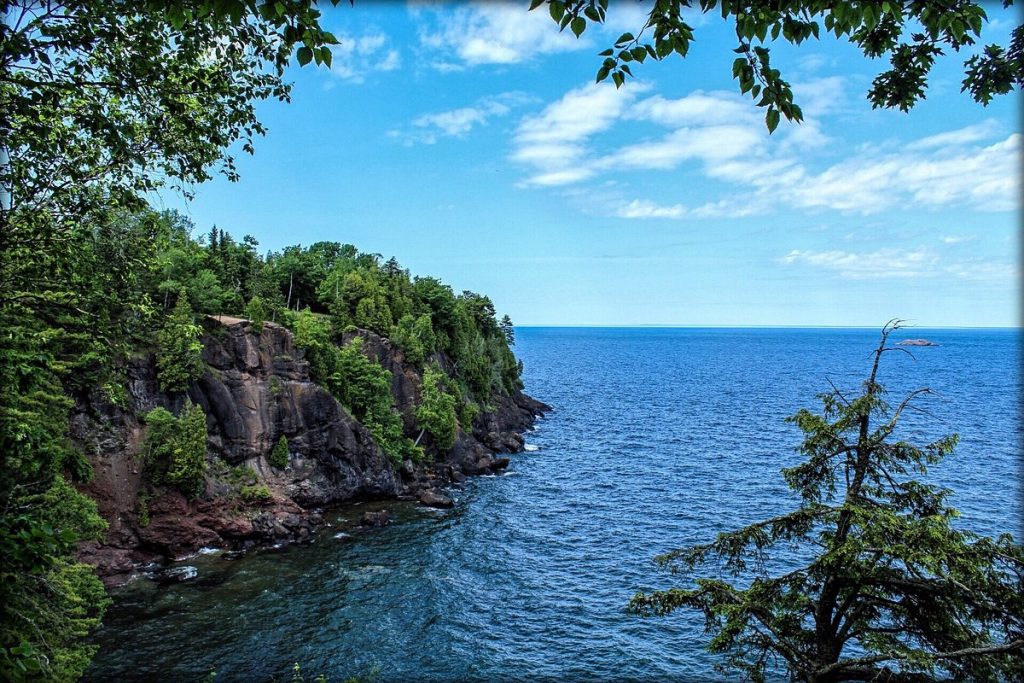
Presque Isle Bay, located on the Presque Isle peninsula, serves as a natural harbor for Erie. In the 1800s, as Lake Erie navigation became more significant, Presque Isle was developed with shipping aids. Currently, the park contains two primary lighthouses. The Erie Harbor North Pier Light was originally a wooden tower built in 1830. It was later replaced with a stronger steel structure from France in 1858, after being damaged by a schooner. This lighthouse still stands on the far eastern side of the park, near the inlet connecting the lake and bay.
The Presque Isle Light was built in 1872 on the northern side of Presque Isle and was illuminated on July 12, 1873. This lighthouse, measuring 74 feet tall, has a red brick house that served as the residence for the lighthouse keeper and later as a park residence. Presently, the United States Coast Guard maintains the lighthouse, which emits a white light to caution ships of the sandy peninsula that extends into Lake Erie. The light station offers public tours on weekends, weather permitting, from Memorial Day through Labor Day. In 1906, a third, smaller lighthouse was constructed by the Erie Waterworks on the Presque Isle Bay side of the peninsula. Nowadays, it stands in the ferry landing for the Presque Isle Water Taxi service, located south of the former waterworks along the multi-purpose trail of the state park on the southeastern side of Presque Isle.
In 1876, the United States Life-Saving Service District 9 established a life-saving station at Presque Isle. William Clark served as the keeper from 1877 until his death in 1891. He was then succeeded by Andrew Jansen, who held the position until 1914. Following the merger of the Life-Saving Service and the Revenue Cutter Service in 1915, the station was renamed LSS Presque Isle and became Coast Guard Station #236 under the newly formed United States Coast Guard. Today, the station, also known as the Erie life-saving station, remains operational and is under the jurisdiction of the Ninth District of the United States Coast Guard.
Modern Day and the Creation of Presque Isle State Park
In the year 1908, Erie began constructing a waterworks on Presque Isle in order to supply the city with clean fresh water. The water was pumped from Lake Erie into two reservoirs located on the peninsula. Here, any impurities in the water were allowed to settle, effectively removing them from the lake water. Once treated, the water was then distributed through the city’s waterlines. A pumphouse, powered by a steam engine, was built in 1917 to pump the water from one basin to the other and across Presque Isle Bay to Erie. This system of providing drinking water for Erie remained in operation until 1949. The pumphouse is currently utilized for controlling zebra mussel infestation and as a concession stand for renting bicycles and quadracycles within the state park.
The Presque Isle beaches, being the only actual “surf” and considered one of the best beaches near Pittsburgh, were a well-known tourist spot even before the “Pennsylvania State Park at Erie” was officially established by the state’s legislature in May 1921. Instead of being managed by the state Department of Forests and Waters, oversight of the park was given to the newly formed “State Park and Harbor Commission of Erie” which included local representation. This decision proved successful as Presque Isle quickly became the most sought after state park in Pennsylvania. It was also one of the first state parks to be located near a city, a trend that would later become popular in the 1960s statewide.
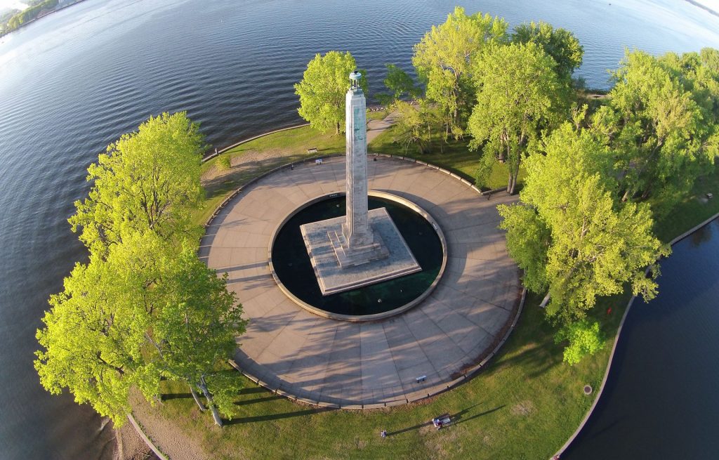
In 1924, the first road was constructed in the park, and currently, the park has a total of 13 miles of roads.The main entrance into the park is through Pennsylvania Route 832, which is also known as Peninsula Drive. The park has been commonly referred to as “Peninsula State Park”. One of the park’s notable features is the Perry Monument, which was built in 1926 near Misery Bay and the burials in Graveyard Pond.
In 1937, state publications officially designated the park as “Presque Isle State Park”, and it quickly became the most popular state park with 1.4 million visitors. The park was expanded in the 1950s to accommodate new roads and parking, which required 3 million square yards of sand dredged from the peninsula’s interior. This created the current marina and also included the construction of three modern bath houses in 1957. In the same year, the state designated Gull Point, located at the eastern end of the peninsula, as a nature preserve.
In 1967, the National Park Service designated Presque Isle as a National Natural Landmark. The independent board which oversaw the park was recommended for dissolution as early as 1930, but it was not officially abolished until January 19, 1971, when the state Department of Environmental Resources (later known as DCNR) was created. In order to combat erosion, more than 50 breakwaters were constructed along the western and northern shore of the peninsula between 1989 and 1992. In 1997, Presque Isle State Park’s Important Bird Area (IBA) was designated as one of the first 73 IBAs in Pennsylvania. As part of the “State Parks 2000” strategic plan by the Pennsylvania Department of Conservation and Natural Resources (DCNR), Gull Point was named a “State Park Natural Area” to provide a resting, feeding, and potentially nesting spot for rare and migratory shorebirds.
The Tom Ridge Environmental Center was established in May 2006 at the entrance of the park. In 2007, the Pennsylvania DCNR Bureau of Parks, which manages all 120 state parks, selected Presque Isle for its “25 Must-See Pennsylvania State Parks” list due to its distinction as Pennsylvania’s sole surfing beach, its designation as a National Natural Landmark, and its rich geological and biological diversity and historical significance. In April 2008, scenes for the movie The Road were filmed at Presque Isle, specifically at Beach 10 as a shoreline location.
On June 27, 2010, an EF0 tornado, as classified by the Enhanced Fujita Scale, caused damage to the state park. The Stull Interpretive Center and a nearby observation platform were affected by downed power lines and trees. As a result, Presque Isle State Park was temporarily closed on June 28 for debris clean-up and reopened the following day. [31]
In October 2012, Hurricane Sandy had reached Presque Isle, causing the park to be temporarily closed due to the forecasted 14-18 feet waves and strong winds. However, the storm ended up being less severe than expected, with only 8-foot waves and lower wind speeds. Despite minor flooding, some fallen trees, and a power outage at the park marina, Presque Isle State Park was fortunate to have escaped the storm with minimal damage.
Geology and Climate
Presque Isle, a curved stretch of land made of sand, was created during the last ice age when the Laurentide Ice Sheet moved into the region where Lake Erie now sits. As the ice sheet retreated northward between 12,370 BC and 12,790 BC, it left behind a moraine made of clay, sand, and gravel, which eventually formed the Presque Isle peninsula. The materials on the peninsula are constantly being reshaped by the movement of waves and are gradually shifting towards the northeast due to longshore drift.
The park’s name, presqu’ ile, is a French term that translates to “peninsula” or “almost an island”. Despite its name, Presque Isle has experienced periods of being cut off from the mainland since 1819, with the longest stretch being from 1832 to 1864. To combat erosion, the state and federal governments constructed concrete seawalls and perpendicular groins in the 1950s. Additionally, in 1992, a series of 58 breakwaters were built to capture sand and slow its eastward movement. Despite these engineering efforts, sand still needs to be relocated from tombolos formed behind the breakwaters, and new sand needs to be brought in annually to replenish the beaches.
The natural bay of Presque Isle is protected by the Presque Isle State Park, providing a spacious harbor for the city of Erie. This bay is often occupied by both recreational and commercial ships from various parts of the world, utilizing the shipping port of the Great Lakes. The establishment of the Saint Lawrence Seaway in 1959 opened up Erie as an international port.
The park’s location in relation to Erie results in a climate similar to that of the city. Both Erie and the peninsula are situated in the snow belt, which extends from Cleveland to Syracuse and Watertown. This results in cold winters with heavy lake-effect snow, but occasional warm spells that cause accumulated snow to melt. The Erie region falls under the humid continental zone, classified as Koppen Dfa. This location by the lake helps to moderate summer heat, with an average of only 3.8 days per year with temperatures above 90 °F . The highest recorded temperature was 100 °F on June 25, 1988. On average, there are 2.5 days per year with temperatures at or below 0 °F. The lowest recorded temperature was 18 °F on January 19, 1994, and February 16, 2015. During winter, ice dunes form along the beaches from snowfall and frozen spray, reaching heights of over 6 feet (1.8 m). These dunes protect the beaches from erosion during winter storms and continue to grow until the surface of Lake Erie freezes.
The Nature Surrounding Presque Isle is Diverse
Ecological Regions and Progression
According to the DCNR, Presque Isle is home to a diverse range of habitats, resulting in a higher concentration of endangered, threatened, and rare species compared to other similarly sized areas in Pennsylvania. The DCNR has identified seven distinct ecological zones within Presque Isle State Park, each with unique plant and animal communities. These zones include Lake Erie, beaches and shoreline, sandy plain and ponds, sand dunes and ridges, marshes and old ponds, heath and sub-climax forest, and climax forest. Lake Erie, which surrounds the park, is the first zone and supports 80 species of fish and at least six species of crustaceans.
The concept of ecological succession is exemplified by the remaining ecological zones, which progress from shoreline to climax forest. The transformation of Presque Isle and its shifting shoreline and dunes largely contributes to this progression. The shoreline, also known as the second zone, is created through the force of waves and maintains a balance between erosion and deposition. The initial vegetation on the new shoreline stabilizes the sand. The third zone consists of the newly formed sandy plain and the ponds within it. These ponds can either erode or be filled with wind-blown sand or drifting dunes. This zone serves as a habitat for various species of plants and animals, including 89 types of Odonata (dragonflies and damselflies) and Lepidoptera, including 35 different butterflies. The state park is also home to 84 different species of spiders.
The fourth zone in Presque Isle State Park is made up of sand dunes and ridges, which form when beach sand is carried by wind and waves and then gets trapped by vegetation. Grasses are the first type of vegetation to grow on these dunes, followed by other plants. This provides a home for various animals such as amphibians, birds, mammals, and reptiles. Some of these dunes eventually turn into more permanent ridges, which can shelter ponds. These features are often remnants of past shorelines, such as the “Long Pond” near the marina which marks the eastern shore from 1862.
The fifth ecological zone is made up of old ponds and marshes. Ponds protected by dunes and ridges are more stable and support a greater variety of plant and animal life. As they become filled with vegetation, they turn into marshes. These old ponds and marshes are known for their high biodiversity. Presque Isle is home to nearly 400 species of terrestrial vertebrates, including 318 different types of birds, 48 mammals, 13 amphibians, and 19 reptiles.
The sixth and seventh ecological regions are known for their shrubs and trees. Presque Isle State Park has a diverse collection of 633 plant species, including 195 monocotyledons, 410 dicotyledons, 5 gymnosperms, 5 horsetails, 13 ferns, and 5 mosses. The sixth zone, also referred to as thicket and sub-climax forest, is formed when shrubs grow on decaying marshes, followed by the growth of small trees. As these trees grow, they provide shade and thin out the thickets of shrubs, eventually leading to the formation of a sub-climax forest. The final and seventh stage is the climax forest, where numerous large trees create a canopy in the forest. It is estimated that this ecological progression takes approximately 500 to 600 years, but visitors to Presque Isle State Park can experience all of these zones within a 5-mile walk.
The Pennsylvania Audubon Society has designated Presque Isle State Park as Pennsylvania’s #1 Important Bird Area (IBA), recognizing it as one of the top birdwatching locations in the state. With a diverse range of habitats on the peninsula, the park provides a haven for over 320 bird species, a number that is impressive when compared to the 925 species found in the entire United States. Among these species, 45 are considered “endangered” or “threatened”, including the piping plover, cerulean warbler, rusty blackbird, and saltmarsh sharp-tailed sparrow. Waterfowl and wading birds can be found at Presque Isle throughout the year. During the summer months, Gull Point is home to four species of gull and three species of tern. The park also plays a significant role in the annual Christmas Bird Count, a tradition in Erie County since 1956, with many volunteers recording their observations within the park. Due to its diverse ecological zones, Presque Isle State Park is home to a wide variety of plant and animal species.
Gull Point Natural Area
For a long time, human involvement has affected the ecology of Presque Isle, dating back to the Erielhonan. Structures like breakwaters and roads have hindered the natural movement of sand, leading to erosion and disrupting natural habitats. Excavations for projects such as waterworks basins and marinas have also caused destruction of habitats, but the annual replenishment of sand helps create new ones. To minimize the impact of humans, one section of the park, known as Gull Point, is closed to the public from April to November.
The Gull Point area within Presque Isle State Park has been designated as a “State Park Natural Area” by the state of Pennsylvania. These designated areas serve as sites for scientific study of natural environments, preserving both unique and typical animal and plant habitats as well as areas of natural beauty.
The area known as Gull Point comprises of 319 acres, with 67 acres designated as the Natural Area and closed to park visitors during peak bird migrations. This sanctuary provides a resting place for migratory and nesting birds, including rare species not typically found in Pennsylvania. Gull Point is strategically located on the Atlantic Flyway, a major migratory route, and some of these birds travel all the way from the Arctic Circle to South America. The birds arrive in November for their long journey south and return in April on their journey north.
Gull Point, formed by the movement of sand, is constantly undergoing changes. Between May 1991 and October 2006, approximately 4.6 acres of land were lost, and if this trend persists, Gull Point may eventually become an isolated island. The construction of breakwaters in 1992 resulted in less sand being added to replenish the beaches. Since 2005, there has been a halt in federal funding for sand replenishment, causing a further decrease in the amount of sand added to the peninsula. As a result, the northern beaches of Gull Point have experienced erosion, while the eastern and southern regions have continued to slowly expand, resulting in an annual net loss of 0.4 acres.
Tom Ridge Environmental Center
The Tom Ridge Environmental Center (TREC) serves as the main entrance and administrative hub for Presque Isle State Park. It also includes interactive educational exhibits, a “Discovery Center”, classrooms, and research laboratories. TREC officially opened on May 26, 2006, and is situated on a 12-acre property overlooking Lake Erie, off Route 832. The center was named after former Pennsylvania Governor Tom Ridge, who grew up in Erie, worked at the park in his youth, and provided funding for the center and various projects at Presque Isle during his term in office.
In 2002, construction was initiated on the center, which had been an idea for 50 years at Presque Isle. The TREC also serves as the headquarters for the Presque Isle State Park since 2005, and houses the offices of the Pennsylvania Department of Environmental Protection’s Great Lakes and Coastal Zone Management programs, the DCNR Recreation and Conservation program, as well as various organizations such as Presque Isle Audubon, Lake-Erie Allegheny Earth Force, Pennsylvania Sea Grant, Presque Isle Partnership, and the Purple Martin Conservation Association. Additionally, the TREC is also home to the Regional Science Consortium, which was founded in 2002 and focuses on coordinating educational and research projects for Lake Erie and the upper Ohio River Basin. This non-profit organization comprises 32 members from various educational institutions, museums, state agencies, conservation groups, and private corporations from Pennsylvania, Ohio, and Ontario.
The Tom Ridge Environmental Center has a total area of 65,000 square feet and features eight research laboratories, including large aquariums for the RSC. It also has classrooms, a “Discovery Center” for hands-on science exploration aimed at younger students, interpretive exhibits showcasing the local flora and fauna, as well as the human history and culture of the region. Additionally, the center has a large-format movie theater, a smaller theater, a gift shop, a cafeteria, and a 75-foot tall observation tower that provides views of Lake Erie. It was designed as an environmentally friendly building and has received a Leadership in Energy and Environmental Design (LEED) rating from the United States Green Building Council. Along with supporting environmental research and education, the center’s purpose is to increase the use of the state park during the off-season.
Parks & Recreation
Aside from the amenities available at TREC, Presque Isle State Park offers opportunities for daytime recreation along the coastlines of Lake Erie and Presque Isle Bay, as well as on its trails and lagoons. Popular summer activities include boating, canoeing, fishing, and water skiing, while hiking, biking, inline skating, and bird watching are among the inland options. Visitors in the winter can engage in ice fishing, ice boating, ice skating, and cross-country skiing. Two of the beaches have volleyball courts, with Beach 6 having 6 courts and Beach 11 having one. The park and TREC do not charge admission fees.
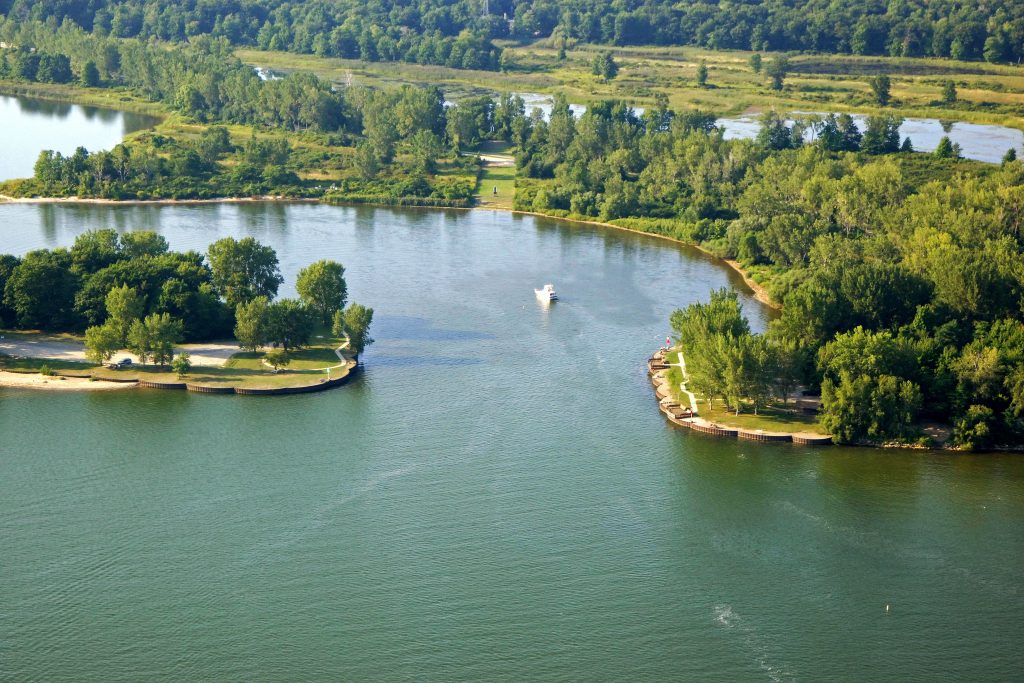
Presque Isle State Park allows various types of boats to be used on Lake Erie. However, boats powered by internal combustion engines are not allowed in the interior lagoons, except for Grave Yard Pond where a concession offers rentals for recreational use including motor and pontoon boats, canoes, and kayaks. Additionally, the park features a marina with 500 slips that can accommodate boats up to 42 feet long, as well as five boat launches. Boat tours are available for visitors to enjoy views of the park, lake, bay, and Erie skyline. It is required for all boats to have a current registration from any state. As Lake Erie’s water conditions can change quickly, boaters are advised to use caution.
Presque Isle State Park allows for water skiing and scuba diving in designated areas of Lake Erie. Water skiing is only permitted in Presque Isle Bay or out on the lake, and it is not allowed within 500 feet of the shoreline. Scuba divers must possess certification and must register at the park office to receive information about the authorized diving locations.
There are two distinct fishing areas within Presque Isle State Park. The first, Lake Erie, is home to a variety of fish such as perch, trout, walleye, bass, and steelhead. The second, Presque Isle Bay, is where muskellunge, northern pike, crappie, and smelt can be found, as well as other fish that migrate from the lake. Additionally, trout fishing is permitted in the two waterworks basins, which are regularly stocked by the Pennsylvania Fish and Boat Commission. While hunting is generally not allowed in the park, controlled seasons for duck and goose hunting in designated blinds are permitted.
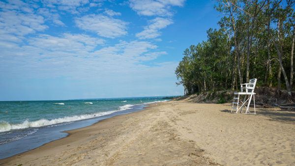
Presque Isle State Park boasts 13 beaches, making it the only place in Pennsylvania where visitors can enjoy surf swimming. These beaches are accessible from Memorial Day to Labor Day, and swimming is permitted during the hours of 10:00 EDT to 20:00 EDT when lifeguards are on duty. Additionally, visitors can take advantage of the many picnic facilities provided at most of the swimming areas.